GEOLOGY & TOPOGRAPHY
The Magaliesberg Biosphere lies in the temperate latitudes with decimal co-ordinate limits 25.60˚N; 26.10˚S and longitude 27.00˚W and 28.30˚E. An elevation of1320m above sea level marks the lowest point of the Biosphere, and the highest elevation is 1852m with the highest mountains being 532m.
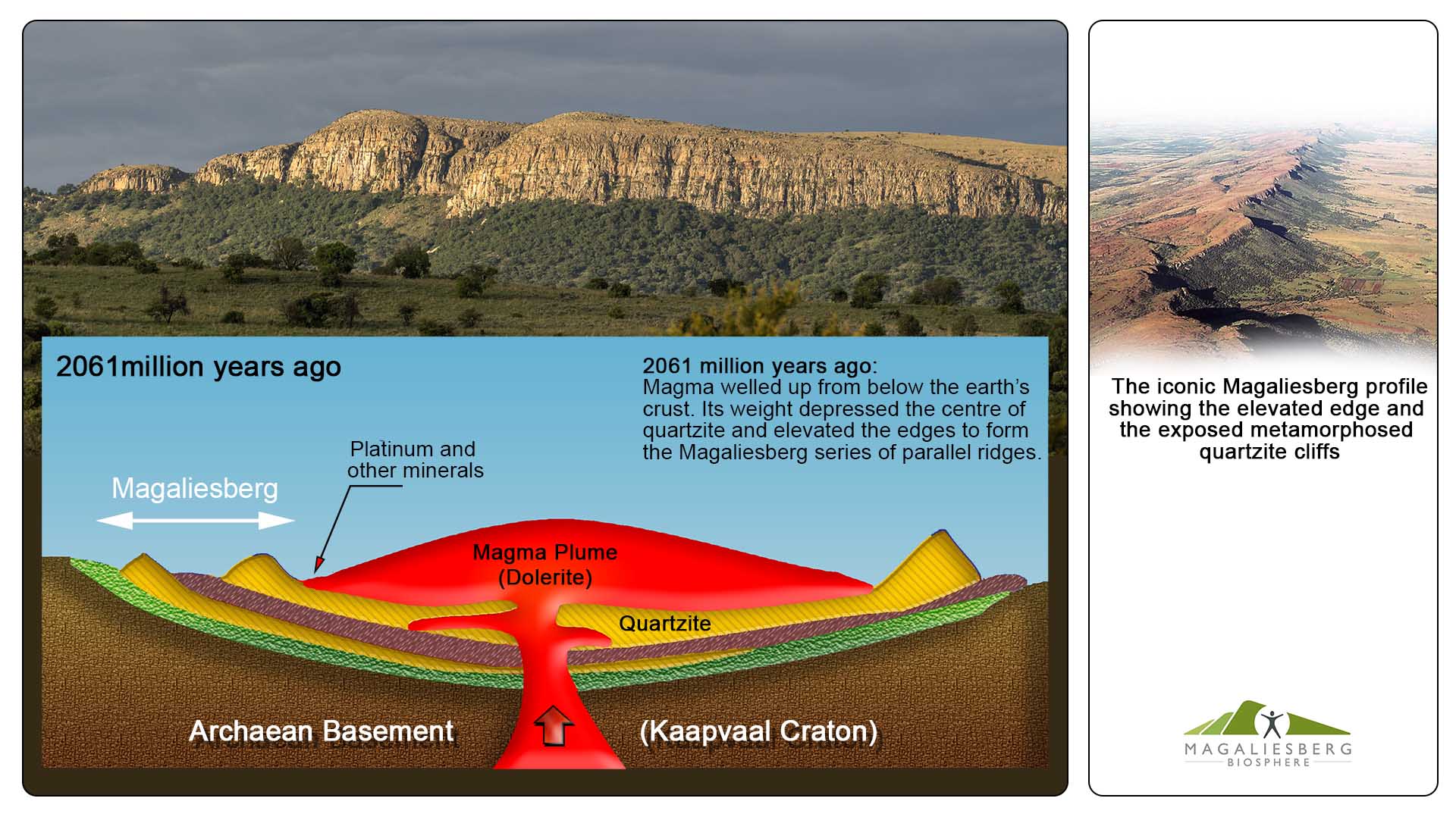
About 2000 million years ago the mountain ranges of the Magaliesberg region were formed when massive intrusions of molten magma steadily formed a 65000 km² expanse of solid igneous rock over and between existing sedimentary layers. Under the weight of the magma, the sedimentary layers (made up of a base-layer of Black Reef, overlaid by semi-soluble dolomite and chert which was later topped by alternate layers of quartzite and shale) tilted upwards through the magma at the edges of the igneous intrusion to form a series of semi-concentric mountain ranges of tilted sedimentary layers at the southern perimeter of the igneous mass. Over millions of years of weathering and erosion, resistant quartzite and shale formed the ridges of the Magaliesberg, Witwatersberg and other smaller chains (Carruthers, 2015).


The resistant quartzite formed more gently tilted north-facing slopes, and the deep kloofs engraved in them, are a result of the erosion of sills and dykes from the igneous intrusion. Geological faulting formed the few poorts that dissect the otherwise continuous ridges, as well as some of the kloofs on the mountain plateau and slopes (Carruthers, 2015). To the north of the Magaliesberg, the periphery of the igneous intrusion, known as the bushveld complex, is made up of mostly norite in this area. It forms flat plains with occasional rocky koppies. Directly south of the Witwatersberg, remains of the Transvaal Sequence form a wide curved band of porous dolomite and chert, characterised by undulating hills dotted with cave formations and small rocky outcrops (Berger, 2006). The dolomite is bordered to the south by the northern edge of the granite dome on which Johannesburg lies.
This unique and varied geology and topography provides a multitude of habitats and ecological niches and micro-climates that support a vast array of biodiversity across the Magaliesberg landscape.

Hydrology
The hydrology of the MB is made up of the following hydrological features : Dams, rivers, streams, waterfalls, springs, small wetlands and groundwater recharge zones. The main tertiary catchment of the region is the Crocodile West and Marico catchment, which drains from the Witwatersrand watershed, northwards right through the dense urban conurbation of Johannesburg, and through some agricultural and mining operations. As a result, the nine main rivers of the region carry heavy loads of sediments, litter and nutrients, and all of the large river ecosystems in the Biosphere have been classified as critically endangered or endangered, according to the National Biodiversity Assessment (NBA) 2011, river ecosystem status, meaning that they have lost much of their value as terrestrial botanical habitat.
Most of the main rivers flow northwards and converge at one of the few poorts in the Magaliesberg range. Two of these poorts, the Hartebeespoort and Olifantspoort, were dammed in the 1920’s and 1930’s respectively. Hartebeespoort dam is 20km², and the Olifantsnek dam 2.5km² in extent. A fair percentage of both of these dams are silted up, and agricultural and urban runoff present dire problems for water quality (Oberholster & Ashton, 2008).The Buffelspoort dam is less silted and less polluted as it drains the perennial streams and runoff from the mountain. These mountain streams provide high quality water and are one of the area’s most important natural resources and ecosystem services.
The topography of an area largely determines where wetlands can potentially form. Generally throughout the Biosphere small wetlands occur in low lying areas along the Moot valley, and along river and stream courses. A series of expansive seasonal grassland wetlands or pans extends southwards from the south-west biosphere boundary. A wetland study conducted as part of the Magaliesberg Protected Environment, Environmental Management Framework, identified six different types of wetlands associated with the mountains. The largest being a natural wetland in a plateau basin of deep alluvial soil between two quartzite ridges, in the Kgaswane Mountain Nature Reserve. In March 2019, this wetland area was declared a RAMSAR SITE, a wetland of international significance.

Other smaller mountain wetlands occur where faults cut across drainage lines on the northern slopes. Patches of a specialist vegetative sponge found at these high elevations, absorbs and retains rainwater and runoff (Gill & Engelbrecht, 2012). Seasonal wetlands, pans and wetlands associated with the kloofs and springs have also been identified. Wetlands are important habitat for many species and provide a filter system for runoff. By retaining and slowly releasing water, they control the rate of runoff, which helps prevent flooding and soil erosion (Driver, et al., 2012).
Areas of dolomite in the Cradle of Humankind are important ground-water recharge areas for the region,that need to be carefully managed for our increasing population and for climate change adaptation.

The hydrological resources of the Magaliesberg Biosphere described here, provide examples of ecological functioning and service provision associated with the Magaliesberg Mountains, which forms an important part of the “ecosystem component” of the valuable biodiversity of the region. The historical alteration of the hydrology, and the densly urbanised upper catchment has resulted in a number of water quality problems in the rivers feeding the Hartebeespoort dam and others flowing through the biosphere. A number of NGO’s and academic institutions in the greater biosphere area, concerned with issues of water quality and quantity and aquatic ecosystems, are doing work to address our water problems. Some of these organisations and the work they do are mentioned on our stewardship pages.

